We left our winter volunteering spot at Sunshine Acres Children's Home in Mesa, Arizona and drove southwest to Yuma, Arizona. This stop serves two purposes; 1) visit friends, and 2) visit the dentist.
Friends we met on the road when we first started this full-time RV'ing adventure in 2018 have purchased homes in Yuma so we like to check in with them. They still RV but have a home base now in Yuma. While we were there, all of us took a day trip across the border to Los Algadones, Mexico. This has become an annual event for us.
 |
| The border between US and Mexico on the other side of the fence |

 |
| Nancy, Kelley, Wes, Al, Mike, Joie, and Roberta |
 |
| Why is everyone's margarita glass empty except mine? |
This trip we parked the RV at the Foothill Village RV Park.

 |
| Most of the snow birds have flown for the season so the park was mostly empty. |


 |
| Al, Joe, Kathy, and Nancy |
We planned to stay three nights in Sun City but it was too hot and without electricity hookups, we couldn't run the air conditioner as much as we needed so we decided to leave a day early.
One the way out of the Phoenix area, we paid $4.05 for diesel at the Costco.
Luckily we could get a night at the Quailwood Greens golf course in Prescott, Arizona.


 |
| We're parked in this section H of the campground among the trees. |
We learned that some friends, we made while doing a Habitat for Humanity build in Fredericksburg, Texas were going to be in the area. Gary and Joanne invited us to join them at Blazin' M Ranch for dinner and a western show.

 |
| Al, Nancy, Joanne, and Gary |

 |
| The guys tried to rope a "steer" |
Dinner was all you can eat Chicken & BBQ Ribs with all the fixin's.


When we went to the office to modify our reservation at the campground we learned that we could add an extra week for just $29 so we ended up staying at this campground for 28 nights! That gave us plenty of time to explore the area.


Here you will see artifacts recovered during the excavation - not replicas, but true pieces of the past. Some tell a story, some are silent. Some prompt us to ask: How did they do that? Or Why?
Our understanding of the past, and how we study it is not static. It is open to critique and change.

 |
| Yucca fiber sandals |

The Archeological Committee of the Yavapai County Chamber of Commerce wanted to collect artifacts for an "exposition of the prehistory of the county." Having sponsored similar projects in the Prescott area, they now looked to the Verde Valley were no work had been done.
Louis R. Caywood and Edward H. Spicer, two graduate students from the University of Arizona, led the excavation of what they would call Tuzigoot. The project remains one of the most important archeological investigations undertaken in the valley.
 |
| Hilltop site before excavation (1933) |


 |
| Verde Valley |
I earned my 48th Junior Ranger Badge.

We left the national monument and stopped off at the river on the way out.
 |
| Tuzigoot River access |

Next up was a stop in downtown Cottonwood for a walk.

 |
| Gateway to the Verde River |

 |
| The cottonwood trees were dropping their stuff and it looked like snow |


We happen to be in town when a lady was there setting up signs for the runners of the Cocodona 250. That's 250 miles of running for 6 days from Black Canyon City to Flagstaff, Arizona! 137 people completed the race with the winner completing in 69 hours! Don't worry, this will not be my new sport!

A tip we found was to take a shuttle bus from the Cottonwood library to Sedona. That way we wouldn't have to try and find parking for our huge truck and save some diesel. We did a scouting trip to see where the shuttle went in town. The shuttle was called CAT - Cottonwood Area Transit.


Blah, blah, blah and we ended up getting out without buying anything! We had almost a month in the area so plenty of time to fit in these "gifts."
Now that we had a better lay of the land from taking the CAT shuttle, we decided to do the Solder's Pass Trail hike. It was 4.5 miles with 839 ft elevation gain.


 |
| Al contemplating the next steps. |
We made it up and inside the cave.


 |
| That one section was the hardest but much easier going down by letting gravity lower our body. |

 |
| The view from sitting within the arch |


After the hike, we walked all the way back to the CAT bus stop. It was about 8.5 miles total. A good hike but I was tired.


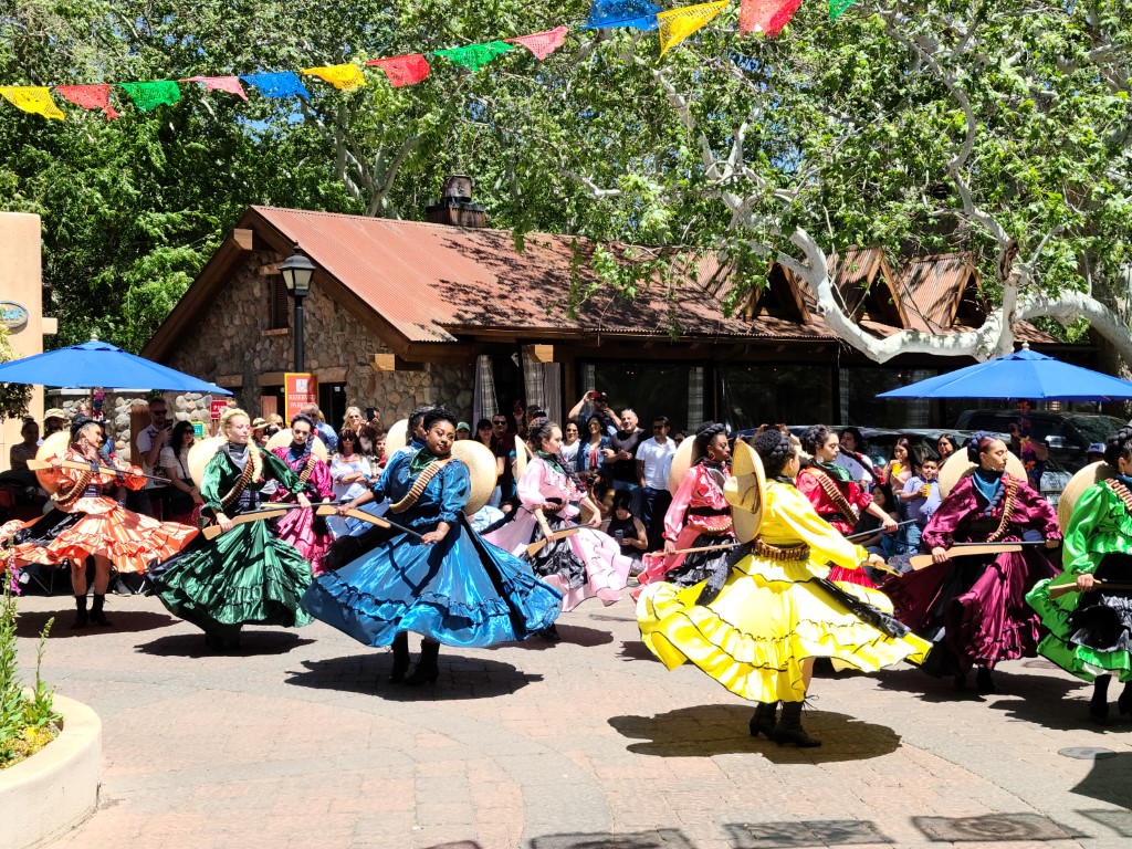


Al wasn't too excited by the dancers but I enjoyed seeing their traditional outfits.


 |
| Visitor's Center |

 |
| How would you like to be walking around with these sandals? |

 |
| Duncan starting off our tour |
The Palatki site has a set of ancient cliff dwellings in the red sandstone cliffs, built from 1100 to 1400 CE by the Sinagua people of the Ancestral Puebloans. The cliff dwellings were built under south-facing overhangs for shelter and winter sun. The Sinagua people planted crops and made pottery in the area. Palatki and Honanki, another nearby archaeological site, had the largest cliff dwellings in the Red Rock formation area from 1150 to 1300 CE.
 |
| Sinagua cliff dwellings |
 |
| Prehistoric grinding surface. Do not stand on this boulder. |


 |
| This man spoke about the ruins and he was very interesting. |


 |
| It is possible to see the hand prints in the "mortar" from the people who built this section |
 |
| View from the cliff dwelling |


 |
| Look below the arch in the rock. |
 |
| Look left of the dark green tree. |

There are pictographs and petroglyphs at the Palatki site, including some that predate the cliff dwellings. Many of the pictographs on the rock walls are from the Sinagua. However, those created by peoples of the Archaic period in North America include some of the more abstract pictograph symbols and drawings that are 3,000 to 6,000 years old, and some of the petroglyphs, estimated to be 5,000 to 6,000 years old.


This snake drawing is thought to be a picture of the rocks in view from this site. They are thought to use these rocks to track the summer and winter solstice and the equinox.


After our tour we got to talking with the couple volunteering for the summer at the visitor's center. Duncan & Linda had just arrived at the park about a week prior and were going to spend the summer in the park. Linda worked in the visitor center and Duncan gave tours. We enjoyed sharing our travel stories so we made plans to meet for lunch another day.
 |
| Sinagua sites in Arizona |


 |
| That's a big guy. Just happy it's not a snake! |

 |
| Look for the dwelling in the dark section of the rock above the tree line |


 |
| Settlers graffiti the rock back in 1825 or 1925? |


 |
| Archaeologists attribute this image to the Hopi. It was likely made during one of their ongoing return visits to this site. |


 |
| Most of the Yavapai pictographs at Honanki were drawn with charcoal. Animals and riders on horses are most common. |
 |
| Back on paved and smooth road again. Ahhh....... |
One of our timeshare gifts was a Safari Jeep tour.


 |
| Our guide was very good. |


 |
| The agave americana plant is known as a century plant because it typically blooms once every 100 years at the end of its life cycle. |
 |
| Photo courtesy of Google Images |
 |
| Yucca |


 |
| Look how long my legs are! |


We really enjoyed our Jeep Tour. Our guide was so knowledgeable about the plants and rock formations we saw.
One day I was in the Club House at the campground and there was a couple performing.


Several Hopi clans and Yavapai communities trace their ancestries to early immigrants from the Montezuma Castle/Beaver Creek area. Archaeological evidence proves that the Hohokam and Hakataya settled around or in the Verde Valley. Clan members periodically return to these ancestral homes for religious ceremonies.


Each group living in the Castle likely had their own room, with roughly 140 square feet on average. Ceilings were at about 5 feet. Peep holes and doorways provided light in the morning and early afternoon, but rooms were dark in the late afternoon and evening.
Women or children likely did the plastering, including annual patching of exterior walls that eroded easily - their hand prints are still visible in the plaster today.

 |
| This tree has been vandalized. Defacing trees is vandalism. Please help us preserve and protect our nation's unique natural and cultural heritage. Do not write on or carve the trees. |


Before the official end of guided tours of the cliff dwelling on October 1, 1951, park rangers had long been aware of and considered what to do about the impacts of so many people walking through the fragile site. If the Castle was going to be off-limits, a model was needed to show and interpret what the structure looked like inside. Created by the National Park Service's Museum Laboratory in Washington, DC, this diorama offered a look at the interior of the Castle and ended damage caused by visitation and vandalism.
Today the model still serves its initial purpose and acts as an artifact of the park's history. It reminds us of the continual work to balance a meaningful experience for today's visitors with preserving this place for people in the future.


 |
| Diorama was inside this little building. |

While touring the various dwellings, we learned about the Three Sisters.
The corn provides tall stalks for the beans to climb so that they are not out-competed by sprawling squash vines. Beans provide nitrogen to fertilize the soil while also stabilizing the tall corn during heavy winds. Beans are nitrogen-fixers meaning they host rhizobia on their roots that can take nitrogen, a much needed plant nutrient, from the air and convert it into forms that can be absorbed by plant roots. The large leaves of squash plants shade the ground which helps retain soil moisture and prevent weeds.
Corn, beans and squash work together nutritionally to offer carbohydrates from corn, protein from beans and healthy vitamins and minerals found in squash.


To protect ancient rock art panels found here, the V Bar V Ranch was acquired by the US Forest Service through a land exchange in 1994.
 |
| All that is left from the old homestead. |
Petroglyphs are pecked, ground, or scratched into the rock surface. "Petro" is Greek for rock and "glyph" means drawing. The V-Bar-V Heritage Site is the largest petroglyph site in the Verde Valley.


A guide tried to explain how the solar calendar worked.


 |
| Notice where the sun shines along the body of the "snake" at different times of the year. |


Varnish bacteria thrive on smooth rock surfaces in arid climates. Perhaps 10,000 years are required for a complete varnish coating to form in the deserts of the southwestern US. In fact, dating of varnished surfaces is of enormous importance to the study of desert landforms and to the study of early humans in America, since many artifacts lying on the ground become coated with desert varnish. And, as we know, several Indian cultures utilized desert varnish to create their marvelous petroplyphs.


We enjoyed the Soldier's Pass hike so much that we invited our friend Bill to come over and hike it with us again.


 |
| This view is parallel to the rock wall |
 |
| Looking back at Bill near the tricky section to enter the cave |


 |
| Bill |


 |
| Can you see me in the upper arch? |


After the hike, Al cooked dinner for Bill, our campground neighbors, and me.
 |
| Al, Bill, Nancy, Barb, and Jerry |
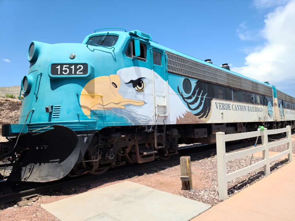
Our second timeshare gift was a ride on the Verde Canyon Railroad which departs from Clarkdale, Arizona.

 |
| At one time the lantern was the only means of communication between a brakeman and engineer. The brakeman would signal the engineer through a wave of the lantern to ensure safety of operation. |
 |
| Caboose |
 |
| There are inside and outside cars |

 |
| I liked that we had reserved seats that were ours for the whole trip. We also had access to an outdoor car. |
 |
| The FP7 locomotives, two of only 10 remaining in North America, are the muscle that pulls the quarter-mile length of passenger cars. The classic iron horses built in 1953 for the Alaska Railroad, debuted on Verde Canyon Railroad tracks on March 8, 1997. |


The train went deep into the canyon to the town of Perkinsville. There wasn't much left to the town but this old train depot and a couple more buildings.


We did not get off the train at Perkinsville as there wasn't anything to do there. On the ride back I tried to be in the outdoor car more but then it started to rain.


 |
| Duncan and Linda |
We had so much fun we met up again one more time for lunch before we left the area.


After the hike we had dinner to celebrate my birthday at Creekside Restaurant in Sedona.


 |
| My birthday dessert |
Here is the area where we spent April and May.

Next we're headed to Vegas to meet up with some friends and do some water skiing at Lake Mead.


